

We'd love to show you the interactive version of this map.
Please visit the desktop version of the site.
Using police helicopter pings to show which suburbs were targeted during lockdown
One council area in the north of Melbourne received disproportionate attention from the police helicopters in 2020 and 2021.
Social media was alive with rumours about police helicopters repeatedly hovering over certain neighbourhoods during Melbourne's lockdown years.
The city's northern and western suburbs were the city's COVID hotspots, but were rumours about these areas also being the target of airborne police surveillance just lockdown paranoia or legitimate observations?
To assess this claim, we were able to collect over a million "pings" from three Victoria Police helicopters during this time. Pings are what active aircraft send out to confirm their location, speed and altitude throughout their journey.
The more we analysed the assembled data, the clearer it became that some of these claims were right.
The first step in this project was, of course, to gather all the "pings" sent out by Victoria Police's three helicopters during 2020 and 2021. The grunt work on this had been carried out by ADS-B Exchange, a crowd-sourced aviation tracker, which displayed these archived results on its website.
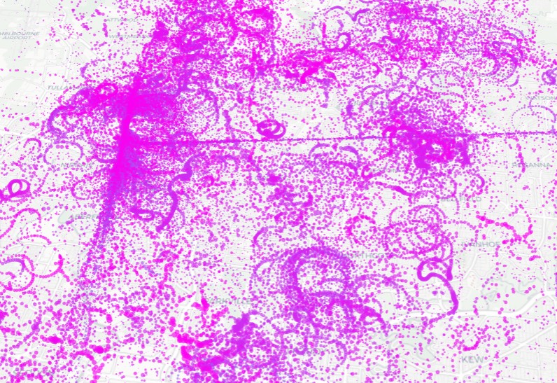
Once we had harvested this data, we then laid it out geospatially. This resulted in a beautiful and intriguing visualisation, especially after a time-scaled colour gradient was added to the series (those earlier in the period appeared blue, for example) and pings sizes were inversely adjusted for speed (to emphasise hovering).
As there were so many pings recorded - well over a million - our maps started to become overwhelming, so we filtered our visualisations in different ways: by focussing on different lockdowns, for example, or on night-time periods.
Ultimately though, what annoys people most about police helicopters - and what shows they are targeting an area - is their hovering, so we refined our dataset down to all pings that were in the slowest 50 per cent of recorded speeds.
We also normalised the recorded speed associated with each ping (compressing all these data points to a scale between 0 and 1) and then inverted these scores, to emphasise the "slower" pings.
This showed that certain parts of the greater Melbourne area had been surveilled much more than others.
This trend became clearer still once we created a heatmap of this data: we rounded the coordinates of each ping up or down and created a new dataframe that tallied a score for each of these rounded coordinates (by amassing all the inverted-normalised ping-speeds for each point).
For each of these rounded coordinates, we then used Python's GeoPy library to find the municipality where each of these pings were sent from.
This starkly revealed how one particular municipality - Hume, a COVID hotspot - had a disproportionate number of visits from the noisy police helicopters during the lockdown timeframe.
By comparison, police barely hovered over areas such as Bayside and Balwyn at all. The score for Hume was even ahead of that recorded by the City of Melbourne - the business district, and site of one police helipad - and Moonee Valley - where the force's main launching site is located.
This data also revealed other peculiarities, such as the unusual amount of time choppers spent over natural landmarks on the outskirts of greater Melbourne. Presumably, this is where they go to idle - deliberately chosen locations that are out of the way, so as not to disturb any local residents.
By being able to bring together and analyse this vast pool of data, we were able to find the answer to one of the questions that had been on locked-down Melburnians' lips.